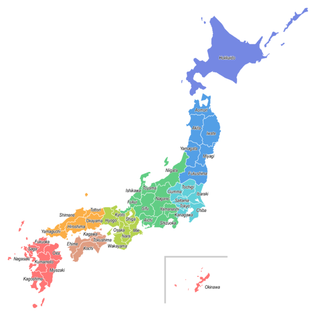
There are 8 regions and 47 prefectures in Japan.
Japan geography
Japan is an island country, that is, a country whose territory consists entirely of islands .
Japan’s territory is centered on the Japanese archipelago (main islands such as Honshu, Hokkaido, Kyushu, and Shikoku), the Izu and Ogasawara Islands extending to the south, the Southwest Islands extending to the southwest (Okinawa main island is the largest island), and northeast. It consists of the northern territory and 6,852 islands . Among them, the Japanese archipelago has a width of about 300 km and a length of about 3500 km.
Although it is not a geographical classification, the Ministry of Land, Infrastructure, Transport and Tourism has set two divisions, “mainland” and “remote islands,” on the 6,852 islands that make up Japan. That is, the five islands of Hokkaido, Honshu, Shikoku, Kyushu, and the main island of Okinawa are called the “mainland,” and 6,847 islands excluding these five islands are called “remote islands.”
Japan, an island nation, is located off the coast of the Far East and East Asia at the eastern end of the Eurasian Continent, and along the coast of the northwestern Pacific Ocean, forming an arc-shaped archipelago as a whole.
This bow-shaped land of Japan is the 62nd largest in the world with a total area of about 378,000 ㎢. About 70% of them are mountainous areas, and about 67% of them are forests (the land area is the area where the Japanese government claims sovereignty).
Japan is an island country and also a mountainous country where mountains occupy about 73% of the country. Therefore, the rivers in Japan have a steeper slope than the extension of the channel, and unlike the rivers that flow on the continent, many rivers flow down at once. Moreover, it is in a heavy rainfall area. Therefore, it is often the case that a deep V-shaped valley is developed in the mountains with strong erosion, and an alluvial fan is developed at the exit from the mountains such as basins and plains. In addition, a plain consisting of thick sedimentary layers is formed near the mouth of the river. Fluvial terraces are often developed from the Chubu region to the Tohoku region.





この記事へのコメントはありません。